
Mud logging, in its conventional implementation, involves the rig-site monitoring and assessment of information that comes to the surface while drilling, with the exclusion of data from downhole sensors.
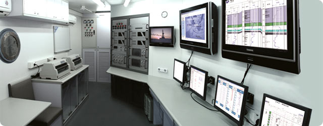
Mud Logging Unit
GEOTECH S.A. Mud Logging Unit is certified by DNV for Zone I & II and is suitable for use in both offshore and onshore rigs. The cabin, the hardware and the software are continiously tested by our quilified team of Manufacturing and Service Engineers before unit deployment. The heart of the Logging Unit is the DAPS – Data Acquisition & Processing System. Our highly trained rig-site geologists and engineers use the powerful and proven DAPS software to acquire and store lithological data which in combination with the engineering data collected from the surface sensors, provide integrated formation evaluation and monitoring of the drilling performance.
Data Acquisition and Processing System: DAPS
DAPS is a comprehensive hardware and software system primarily intended for Mud Logging. The system consists of an array of sensors installed on a drilling rig, a data acquisition system installed inside the mud logging unit (DAPS BOX) and a real-time data acquisition and processing system consisting of the DAPS SOFTWARE and the DAPS SERVERS.
DAPS can measure, display and record the Drilling and Mud parameters, as well as the parameters of the FID Hydrocarbon Analysis system. DAPS is based on a compact industrial Ethernet hardware platform running on .NET Oracle Server architecture.
DAPS displays are a combination of alpha-numeric and graphical data items that can be configured by the end user in order to include analog, digital and calculated parameters. It also allows the operator, through the screen interface, to select and use any available parameter on the screen. Calculated values such as Flow, ECD, Dxc and lag depth can be displayed and/or sent directly to any printer.
Applications
icon Collecting drill cuttings.
icon Describing the cuttings (type of minerals present).
icon Interpreting the described cuttings (lithology).
icon Estimating properties such as porosity and permeability of the drilled formation.
icon Maintaining and monitoring drilling-related and safety-related sensing equipment. Measuring of drilling rates and parameters.
icon Estimating the pore pressure of the drilled formation.
icon Collecting, monitoring, and evaluating hydrocarbons released from the drilled formations.
icon Assessing the producibility of hydrocarbon-bearing formations.
icon Maintaining a record of drilling parameters.
icon Gas Detection.